DECEMBER 13-14, 2002
Introduction
A strong storm moved northeast from the lower Mississippi Valley to the Ohio Valley on the 13th, then shifted east off the east coast on the 14th. Across most of central New York and northeast Pennsylvania the precipitation with this system fell mainly as rain, but a band of heavy snow developed across the far west Saturday morning, with up to 8 inches of snow being reported in a band from western Chemung county northeast to Yates county.

The precipitation changed from rain to snow over the western counties during Saturday morning, once heavy precipitation became established. The profiler at Pinnacle provided good real-time information on the occurrence of the change-over, which occurred at Pinnacle around 11 UTC on the 14th.

Standard Weather Maps
500 mb heights
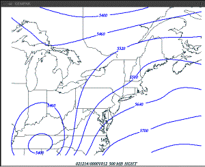
12 hr Eta forecast 500
mb heights verifying at 12/14 00z
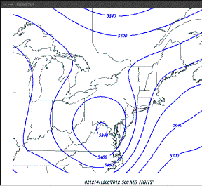
12 hr Eta forecast 500
mb heights verifying at 12/14 12z
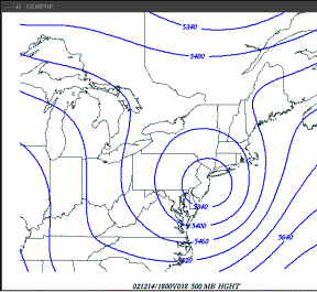
18 hr Eta forecast 500 mb heights
verifying at 12/14 18z
700 mb heights
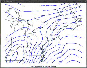
12 hr Eta forecast 700
mb heights verifying at 12/14 00z

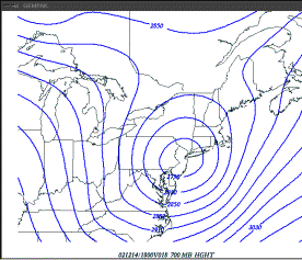
12 hr Eta forecast 700
mb heights verifying at 12/14 12z
18 hr Eta forecast 700
mb heights verifying at 12/14 18z.
Mean sea-level pressure
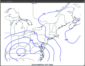
12 hr Eta forecast
mean sea-level pressure verifying at 12/14 00z
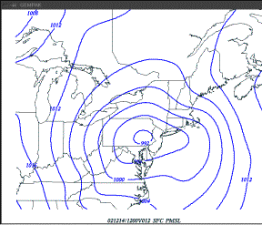
12 hr Eta forecast
mean sea-level pressure verifying at 12/14 12z
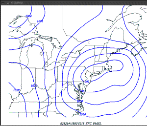
18 hr Eta forecast
mean sea-level pressure verifying at 12/14 18z
In summary, surface low pressure tracked northeast into the Ohio Valley on the 13th, the re-developed off the mid-Atlantic coast on the 14th, as a deep upper-level low pressure system tracked across Pennsylvania. The low deepened as it moved north up the Ohio Valley, but did not deepen rapidly upon reaching the east coast on the morning of the 14th. The storm track was favorable for a heavy snow over portions of central New York.
The following are Eta forecast soundings for the event.
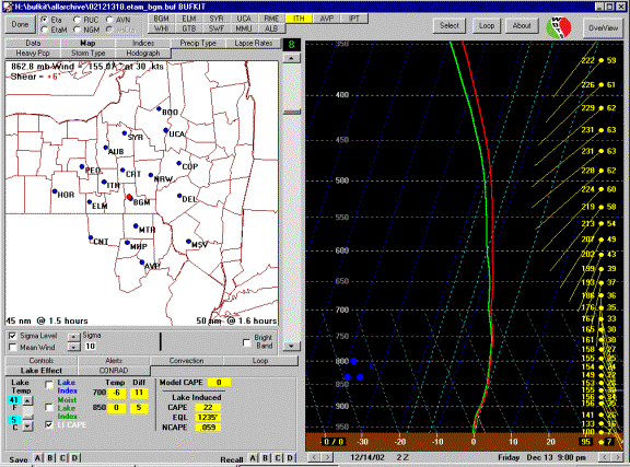
14 hr Eta forecast
sounding at BGM verifying at 12/14 02z.
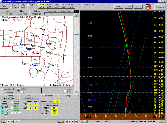
12 hour Eta forecast
sounding at ELM verifying at 12/14 14z.
These soundings indicated very marginal temperatures for snow through-out the lifetime of the system, with isothermal conditions near 0 degrees C through a deep layer of the lower troposphere. This would be a case where rain would change to snow at locations where intense vertical motion could be focused. The rest of this case study will focus on the mechanisms for the development and focusing of intense vertical motion with this system.
Part 1. Late
afternoon and evening of 12/13.
During the late afternoon and evening on the 13th, a band of moderate to heavy precipitation approached the forecast area from the south, as the primary low-pressure system moved northeast toward the Ohio Valley. The precipitation was mostly in the form of rain, however heavy rain turned to a burst of heavy snow across the mountains of central Pennsylvania as the precipitation approached the area. The precipitation was not quite as heavy across northeast Pennsylvania and central New York, and therefore remained mostly rain, although some wet snow mixed in at times. The following figures show radar reflectivity composites, which show the band of moderate to heavy precipitation moving north from Pennsylvania across the forecast area during the late afternoon and evening on the 13th.
MISSING
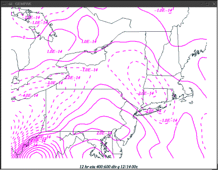
The following figure shows a 6-hour Eta forecast of Q vector divergence verifying during the afternoon on the 13th. Note the band of Q vector convergence (negative values), moving north across Pennsylvania. The leading edge of this lift was not producing precipitation, since the air-mass was initially too dry to support precipitation, however precipitation would begin after this lift occurred for a few hours.
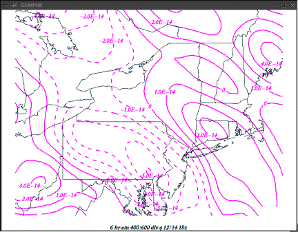
6 hour Eta forecast 400 to 600 mb divergence of Q verifying 12/13 18z.
By 00z this initial band of Q vector convergence had moved north of southern New York and appeared to be weakening.
12 hour Eta forecast 400 to 600 mb Q vector convergence verifying 12/14 00z.
This first band of forcing was associated with a short-wave trough moving north ahead of the main upper-low (still located well to the south), and a band of warm-air advection. The following two figures show the patterns of lower-tropospheric temperature advection and mid-tropospheric vorticity advection forecast at 00 UTC on the 14th.
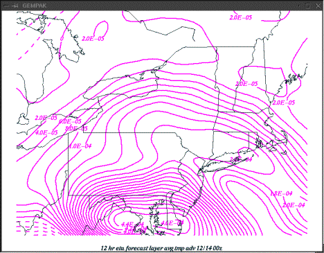
12 hour Eta forecast temperature advection between 800 mb and 600 mb, verifying at 12/14 00z.
Note the weak band of warm advection indicated from southern New England back toward southern New York. A much stronger band is approaching from the south, and is currently located over northern Virginia.
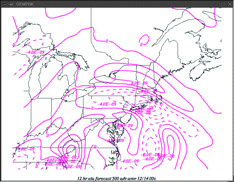
12 hour Eta forecast 500 mb vorticity advection verifying at 12/14 00z.
A band of PVA is moving north of the forecast area across northern New York at this time, while other bands of PVA are located to the south.
In summary, the large-scale forcing over northeast Pennsylvania and central New York during the evening was modest. Warm-air advection was occurring, but was stronger to the south. A band of mid-tropospheric PVA swept quickly across the area during the late afternoon, but was north of the area by 00z.
Next, lets look at the potential for localized banding and intense precipitation:
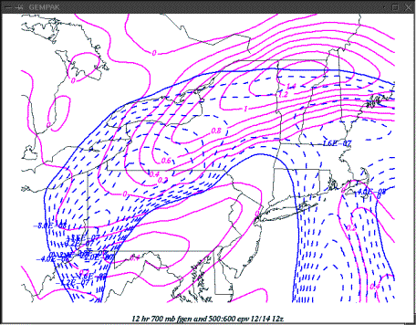
The following figure is a cross section of frontogenesis and EPV extending from Pennsylvania through upstate New York at 00z on the 14th. A sloping zone of strong frontogenesis is evident, with a layer of negative EPV above the frontogenesis. This is a favorable configuration for banding.
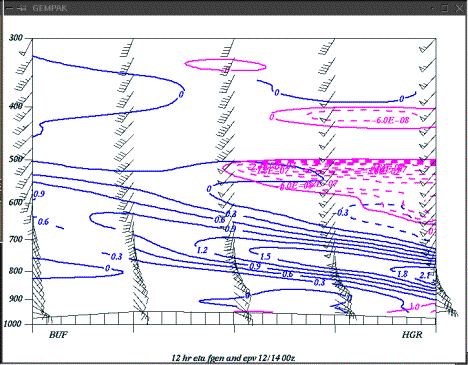
A 12-hour Eta forecast cross section from Hagerstown Md to Buffalo NY of frontogenesis (blue) and negative EPV (purple).
The next figure shows a plan view of 700 mb frontogenesis and 500 to 600 mb layer negative EPV verifying at 00z on the 14th. Clearly, favorable signatures are in place for banding across Pennsylvania at this time.
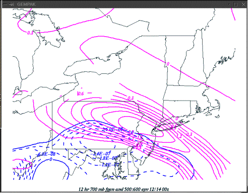
12-hour Eta forecast 700 mb frontogenesis and 500 to 600 mb layer negative EPV at 12/14 00z.
Since enhanced upward motion can typically be expected on the warm side of a frontogenesis maximum, it appears that this configuration is favorable for heavy banding of precipitation over southern and central Pennsylvania. Recall that a heavy burst of rain changing to snow occurred across southern and central Pennsylvania around this time. The question now becomes: will this move north across northeast Pennsylvania and central New York?
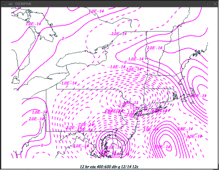
The next figure shows Eta forecast 400 to 600 mb Q vector convergence, indicating the large scale forcing, verifying at 12/14 06z. Note that two favorable areas are indicated, one over lakes Erie and Ontario, and another to the south over southwest Pennsylvania. There is no apparent large-scale forcing for upward motion over northeast Pennsylvania and central New York.
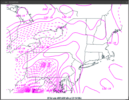
18-hour Eta forecast 400 to 600 mb divergence of Q verifying 12/14 06z.
The next two figures examine the potential for intense banding of heavy precipitation over northeast Pennsylvania and central New York at 06z on the 14th. The first figure shows a cross-section of frontogenesis and negative EPV from PHL to SYR. A sloping maxima of frontogenesis is indicated across the area, with an unstable region (as indicated by negative EPV) located just above the frontogenesis. The next figure shows a plan-view of the same two fields, indicating a favorable configuration for intense banding, with a region of negative EPV located just above a well defined frontogenesis band.
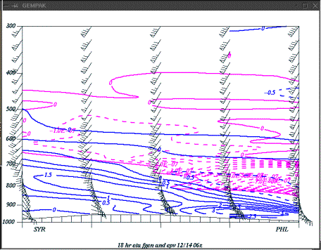
18 hour Eta forecast cross-section from PHL to SYR of frontogenesis (blue) and negative EPV (purple) verifying at 12/14 06z.
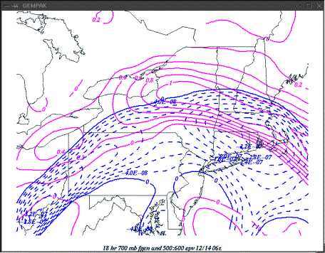
18 hour Eta forecast 700 mb frontogenesis and 500 to 600 mb negative EPV, verifying at 12/14 06z.
The next series of figures show the layer average 600 mb to 500 mb relative humidity, as forecast by the Eta, at 18z on the 13th, 00z on the 14th, and 06z on the 14th. Note that the band of highest relative humidity moves very rapidly north from Pennsylvania across New York State during this period, with strong drying (the dry slot) sweeping northward in the wake of the band of high relative humidity. Negative EPV typically develops in the dry slot, as the drying aloft destabilizes the atmosphere, resulting in more steeply sloping theta-e surfaces. A comparison between the plan view maps of EPV, and these relative humidity plots confirms that relationship, as the leading edge of negative EPV corresponds well with the leading edge of the dry slot. Typically, intense bands can be expected to form at the leading edge of the dry slot and negative EPV.
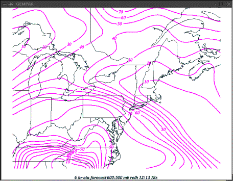
6-hour Eta forecast 600:500 mb average relative humidity 12/13 18z.
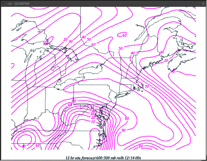
12-hour Eta forecast 600:500 mb average relative humidity verifying 12/14 00z.
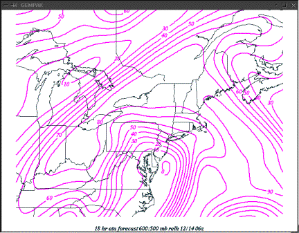
18-hour Eta forecast 600:500 mb average relative humidity verifying 12/14 06z.
The next figure shows a composite of radar reflectivity over the northern mid-Atlantic region at 06z on the 14th.
MISSING
In summary, signatures for banded precipitation were in place from 18z on the 13th through 06z on the 14th across Pennsylvania and New York. These favorable signatures manifested themselves as a burst of heavy snow over central Pennsylvania during the late afternoon on the 13th. However, the signatures did not manifest themselves as intense bands over northeast Pennsylvania and central New York later that evening. One reason may have been that the dry slot advanced very rapidly north across the area during the evening on the 13th. By the time the atmosphere had become moist enough to support precipitation, the favorable large-scale forcing was almost out of the area, and the mid-levels of the atmosphere were drying rapidly. It is important to realize that CSI theory only works in a saturated atmosphere, therefore once the area was located well within the dry slot, intense bands of heavy precipitation did not occur, despite the presence of negative EPV at mid-levels.
Part 2. The
morning of 12/14/02.
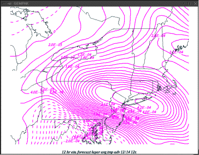
By 12z on the 14th, the large-scale forcing for upward motion began to look more favorable for northeast Pennsylvania and central New York once again. The next figure shows Eta 12-hour divergence of Q in the 600 mb to 400 mb layer. Note the large area of Q vector convergence (negative values) covering all of central New York and Pennsylvania, with the largest values in Pennsylvania.
12 hour Eta forecast 400 to 600 mb divergence of Q verifying at 12/14 12z.
The next two figures show the Eta forecast lower tropospheric temperature advection pattern and mid-tropospheric vorticity advection pattern across the area at 12z on the 14th.
12-hour Eta forecast 800 mb to 600 mb average temperature advection verifying at 12/14 12z.
12-hour Eta forecast 500 mb vorticity advection verifying at 12/14 12z.
By 12z on the 14th, the vorticity advection and lower-tropospheric thermal advection patterns had become aligned, both indicating favorable conditions for large-scale lift across the entire forecast area. The chances for more widespread precipitation appear to be better at 12z on the 14th than they were at 06z on the 14th. Next, lets look at the potential for a heavy band of precipitation located within this area of large-scale lift.
The next figure shows a cross-section of frontogenesis and negative EPV taken normal to the isotherms from ABE to BUF at 12/14 12z. A sloping area of frontogenesis is evident, with a region of negative EPV located above. The frontogenesis appears to be a bit lower than what was forecast for the previous night.
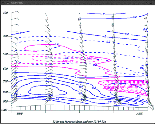
12 hour forecast frontogenesis (purple) and negative EPV (blue) from ABE to BUF, verifying at 12/14 12z.
The next figure shows the 12-hour Eta forecast of average relative humidity in the layer between 600 and 500 mb. This layer corresponds to the layer where negative EPV is forecast over central and western New York.

12 hour Eta forecast of mean relative humidity between 600 and 500 mb.
Note that the dry slot now appears to be located over the Hudson Valley and New England. Meanwhile, more saturated conditions are forecasted over western and central New York. The negative EPV area extends into this saturated region.
The next figure shows a plan view of 700 mb frontogenesis and 500 to 600 mb layer average EPV, verifying at 12/14 12z. Note the favorable signature over central and western New York, where frontogenesis and negative EPV are both maximized. Recall that these are also both maximized within the nearly saturated region indicated on the previous figure.
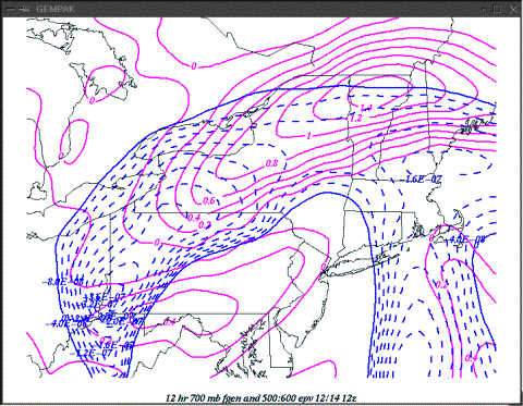
12-hour Eta forecast 700 mb frontogenesis and 500:600 negative EPV verifying at 12/14 12z.
Clearly, these figures indicate the potential for a band of heavier precipitation located on the northwest edge of the area of large-scale forcing, roughly along the northwest boundary of our CWA.
The following figure shows a composite reflectivity image from 12/14 12z, showing where the band of heavy snow was developing at that time.
MISSING
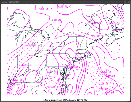
By 18 UTC on the 14th, the large-scale forcing was beginning to weaken and move off the east. The next figure shows an 18-hour Eta forecast of 600 mb to 400 mb Q vector convergence verifying at 12/14 18z.
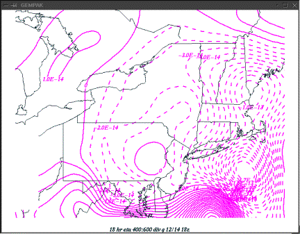
12 hour Eta forecast 400 to 600 mb divergence of Q verifying at 12/14 18z.
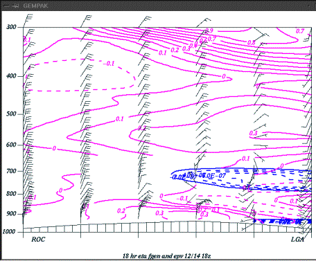
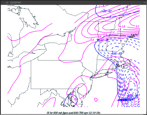
The next two figures show cross-sections and plan views of frontogenesis and negative EPV verifying at 12/14 18z. Note on the cross-section that the frontogenesis is weakening and lowering by 18z on the 14th. The cross section shows no more linkage between the unstable air and the frontogenesis over northeast Pennsylvania or central New York.
The final figure shows composite reflectivity over the northern mid-Atlantic region at 12/14 18z. Note that a diffuse band of snow remains over central New York, however no heavy precipitation signatures remain.
MISSING
SUMMARY
In summary, strong signatures for heavy bands of precipitation over northeast Pennsylvania and central New York were evident with the winter storm of December 13-14, 2002. The marginal temperatures with this storm indicated that intense precipitation rates would probably be required for significant snow to occur. The rapid northward movement of the dry slot during the evening on the 13th across central New York resulted in a very small time period during which the frontogenesis and negative EPV were collocated with an area of large-scale forcing for upward motion and deep saturation. This may have been the primary reason why organized, intense bands of heavy precipitation did not form over northeast Pennsylvania and central New York during the evening on the 13th. By contrast, frontogenesis and negative EPV became collocated with large-scale forcing and deep saturation for an extended period under the northwest quadrant of the storm (the deformation zone) during the morning on the 14th, resulting in a several hour period of heavy snow.