December 25th, 2002
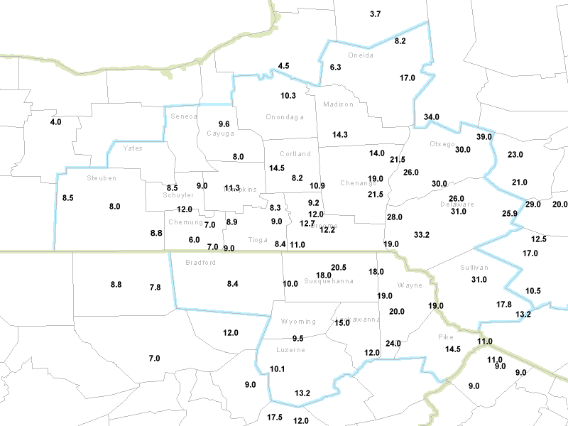
A major snowstorm moved up the east coast on Christmas Day, 2002. Widespread snowfalls
of a foot or more occurred across much of central New York and northeast Pennsylvania,
with amounts as high as 30 inches reported over the northwest slopes of the Catskills.
This case study will focus on 4 aspects of forecasting the storm. 1) A review of some
basic weather maps associated with the storm. 2) A review of diagnostics that were used
to forecast the banded nature of the snowfall. 3) A brief model comparison between the
Eta, GFS and our local workstation Eta forecasts. 4) A look at the performance of the
short-range ensemble forecasts (SREFs).
1. Basic Maps
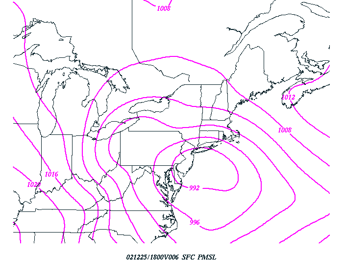
The Christmas day storm occurred as a deep area of low pressure moved up the east coast.
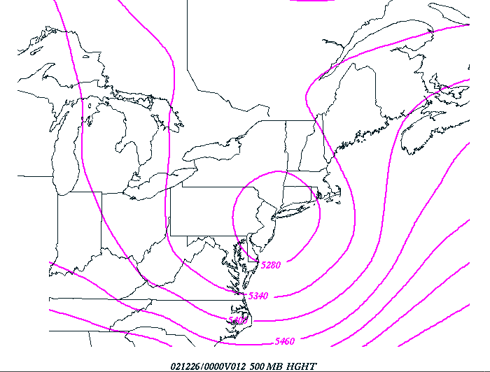
The following figures show surface pressure and 500 mb height forecasts from the 12z 12/25
run of the Eta model.
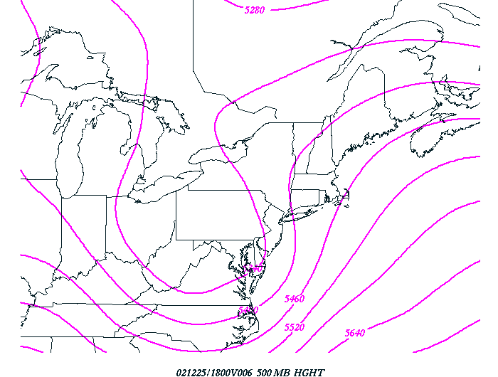
12-hour Eta foreast 500 mb heights verifying at 18 UTC 12/25/02.
6-hour Eta forecast mean sea-level pressure verifying 18z 12/25/02.
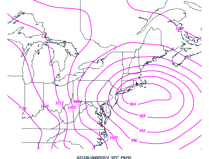
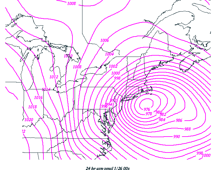
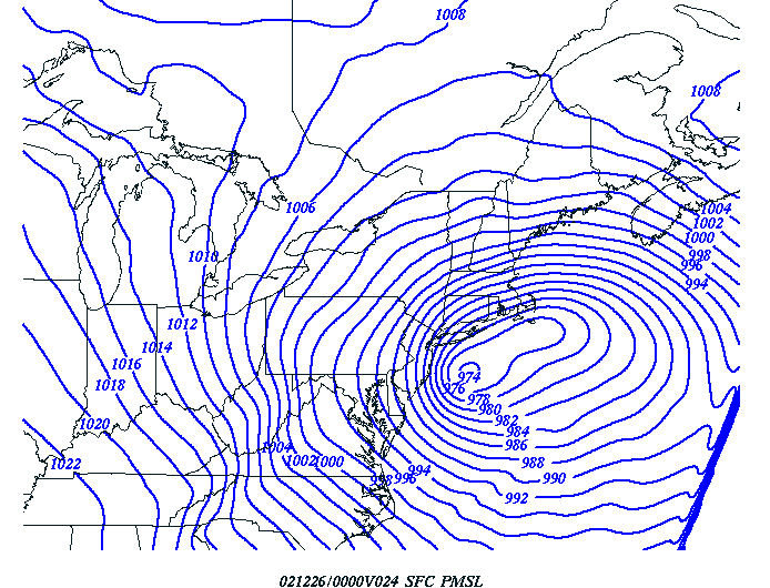
12-hour Eta forecast mean sea-level pressure verifying 00z 12/26/02.
The Eta forecast surface pressure of just under 984 mb was actually too weak. The next
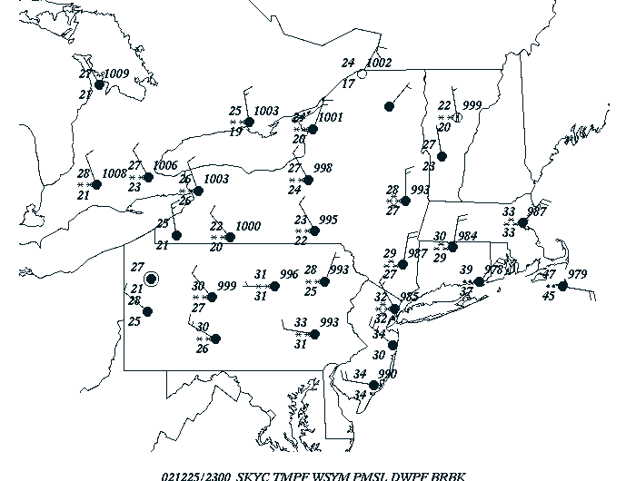
figure shows a station plot from 23 UTC on the 25th. In any case, the surface low was
forecast to deepen around 8 mb between 18z and 00z. The actual deepening rate was
greater.
Surface plot at 2300 UTC on December 25th, 2002.
Note the 978 mb pressure forecast over southeast Connecticut and the 979 mb over Nantucket
island. These indicate that the central pressure of the storm south of long island was
likely in the mid 970s at this time.
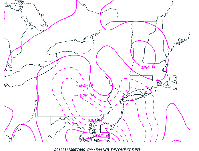
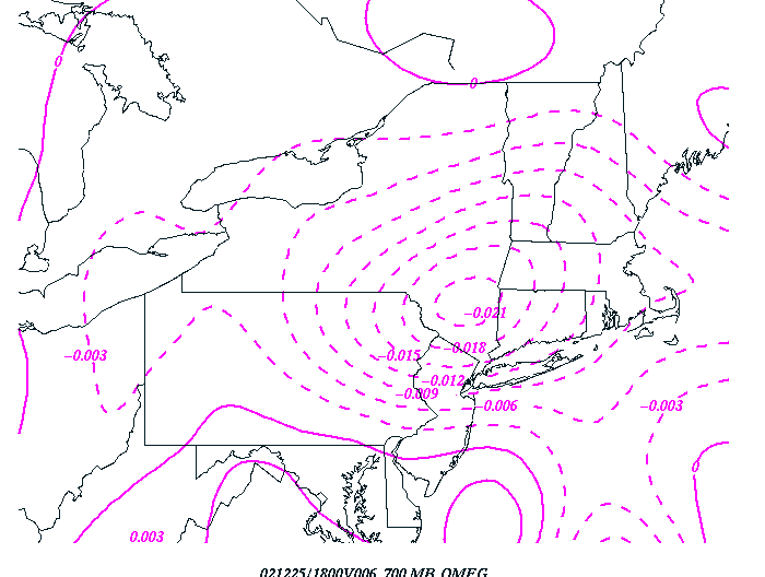
The resultant q vector divergence (large-scale forcing) and omega patterns are shown in
the next four figures.
6-hour Eta forecast 400 to 500 mb q vector divergence at 18 UTC 12/25/02.
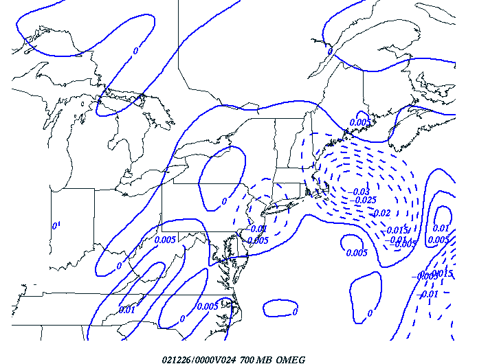
6-hour Eta forecast 700 mb omega at 18 UTC 12/25/02.
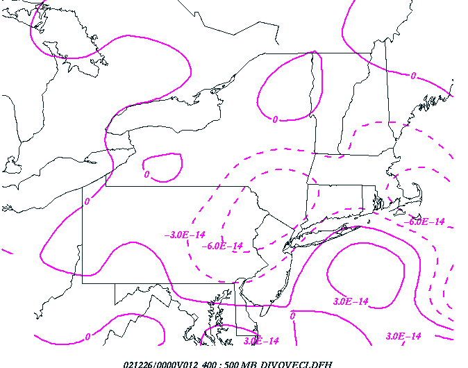
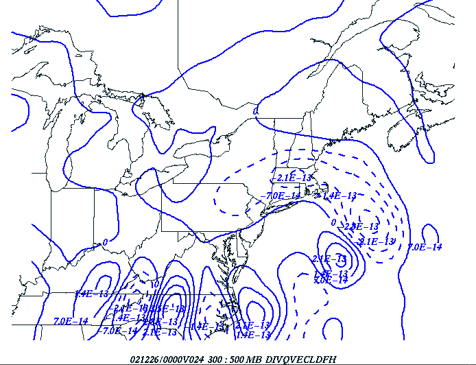
12-hour Eta forecast 400 to 500 mb q vector divergence at 00 UTC 12/26/02.
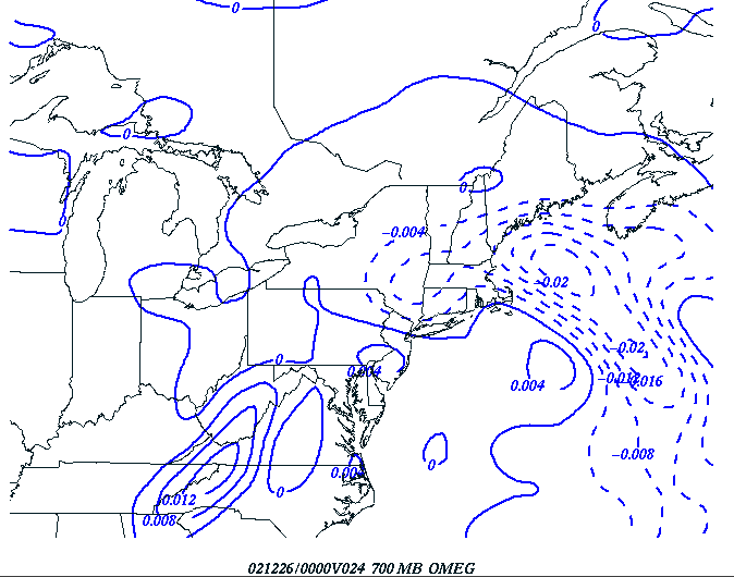
12-hour Eta forecast 700 mb omega at 00 UTC 12/26/02.
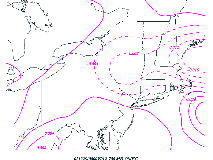
Strong large-scale forcing was moving northeast along the east coast between 18 UTC and
00 UTC. The strongest values of omega were off-set to the northeast of the large-scale
forcing at 18 UTC, indicating the importance of frontal-scale lift (frontogenesis forcing)
at that time. By 00 UTC, the q vector divergence and omega seem to be better aligned,
however the maximum of omega was still located to the north of the maximum of q vector
convergence.
2. Banded snowfall diagnostics.
The Christmas storm exhibited all of the features typically associated with intense
mesoscale banding of heavy snow. The following two figures show radar imagery from the
KBGM WSR-88D at the height of the storm late in the afternoon on the 25th. Note the
intense snow bands.
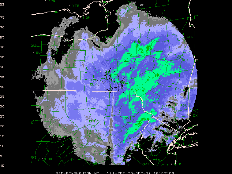
Radar reflectivity at 18 UTC, December 25th, 2002.
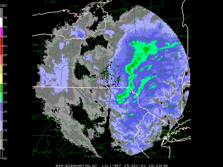
Radar reflectivity at 2000 UTC, December 25th, 2002.
Snowfall rates of 2 to 4 inches per hour were occurring under the strongest of these
bands over northeast Pennsylvania and the western Catskill mountains. The following
figures show Eta forecasts of frontogenesis and equivalent potential temperature (EPV)
from the afternoon on the 25th.
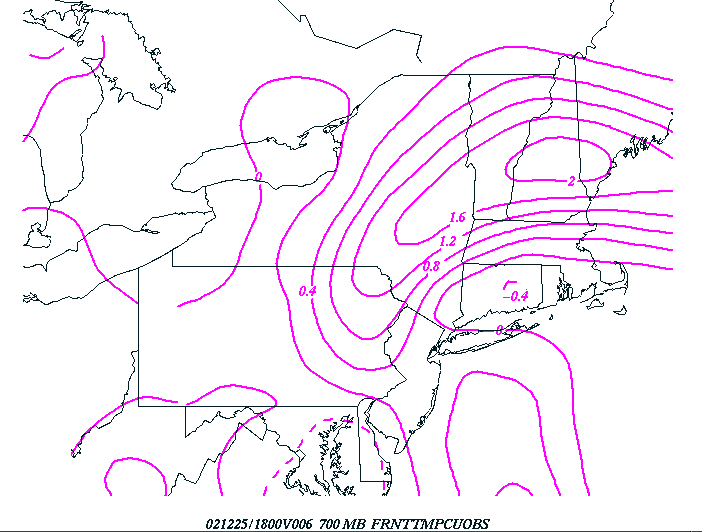
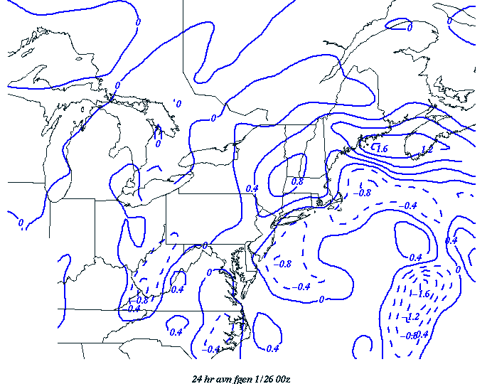
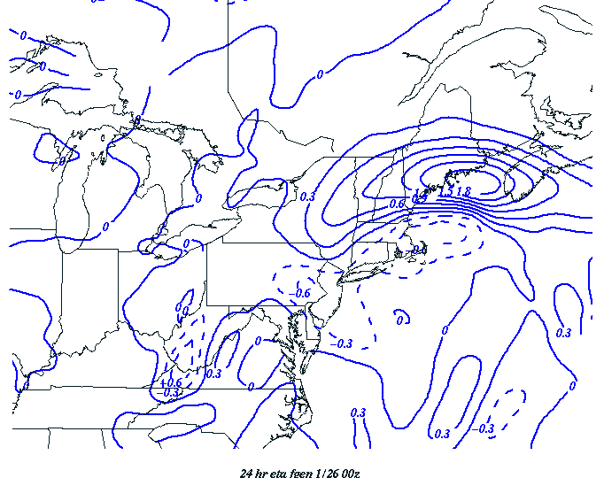
Eta 6 hour forecast of 700 mb 2-D frontogenesis verifying at 18z on 12/25/02.
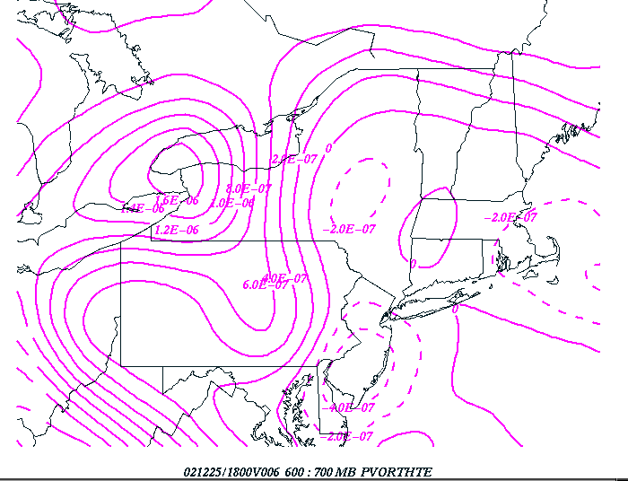
Eta 6-hour Eta forecast 600 to 700 mb EPV at 1800 UTC 12/25/02.
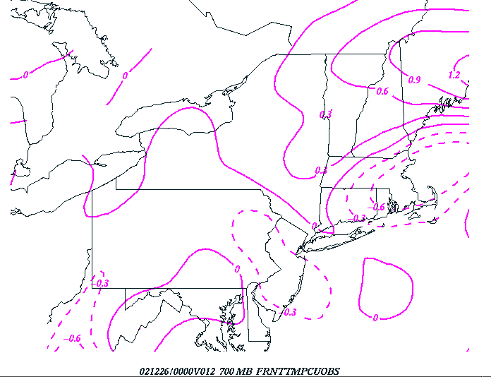
12-hour Eta forecast 700 mb frontogenesis at 00 UTC, 12/26/02.
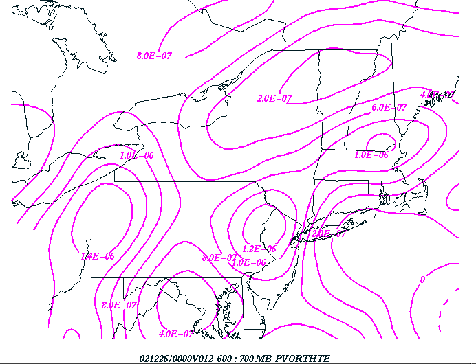
12-hour Eta forecast 600 to 700 mb EPV at 00 UTC, 12/26/02.
At 18 UTC, negative EPV was collocated with the southern edge of the frontogenesis over
the western Catskills; a classic set-up for intense banding of heavy snow in that area.
By 00 UTC, the Eta was no longer forecasting any negative EPV (at least in the 600 to 700
mb layer) over the area, although a southeast-northwest oriented tongue of lower values
was still aimed from eastern Long Island toward the Hudson Valley. The banding had become
less intense by 00 UTC, although some banding was still occurring.
The following figure shows a cross-section of frontogenesis and EPV, taken from LGA to
SYR, at 18 UTC on 12/25/02. Note the classic configuration showing negative EPV located
just above the sloping frontogenesis over central New York.
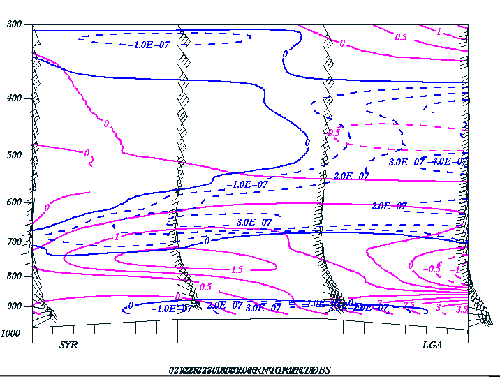
6-hour Eta forecast frontogenesis and negative EPV from LGA to SYR at 18 UTC, 12/25/02.
3. A comparison between the Eta, GFS and workstation Eta forecasts.
The Eta model consistently forecast more snow farther north and west than the GFS, which
turned out to be correct. Our local BGM workstation Eta quantitative precipitation
forecasts (qpf's) tended to more closely resemble the GFS forecasts with this event
(recall that winter 2002 version of our workstation Eta was being initialized from the
GFS initialization, with the Eta physics package). This would imply that the model
initialization may have been the key factor that produced the farther southeast solution
of the GFS/workstation eta.
The following are 24-hour forecasts of mean sea-level pressure and qpf from the Eta, GFS
and workstation eta, verifying at 00 UTC, 12/26/02.
24-hour GFS mean sea-level pressure verifying at 00 UTC 12/26/02.
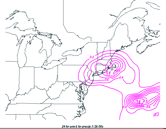
24-hour GFS 6-hour precipitation verifying 00 UTC, 12/26/02.
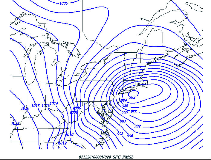
24-hour Eta mean sea-level pressure verifying at 00 UTC 12/26/02.
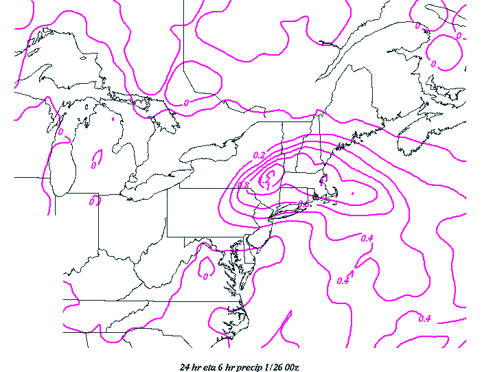
24-hour Eta 6-hour precipitation verifying 00 UTC, 12/26.
24-hour workstation eta mean sea-level pressure verifying at 00 UTC, 12/26/02.
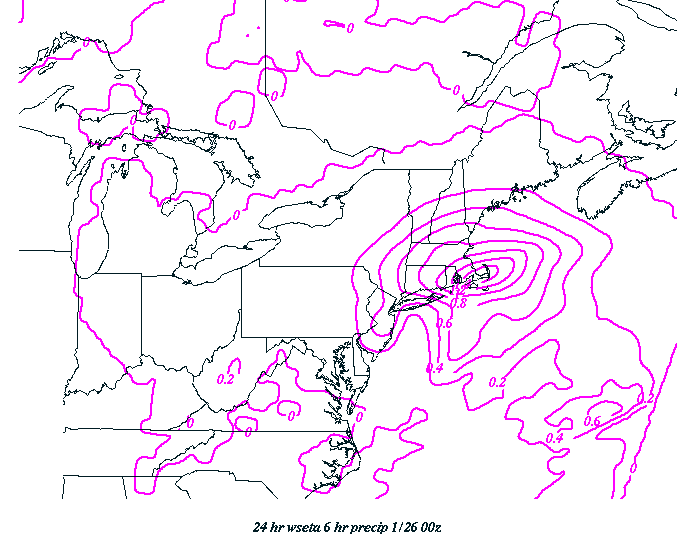
24-hour Workstation Eta 6 hour precipitation verifying 00 UTC, 12/26.
The 3 models positioning of the surface low were all quite similar, with the Eta being
slightly weaker but also slightly farther to the northwest than the GFS or the workstation
Eta. The Eta clearly had significantly more precipitation farther to the northwest than
either the GFS or the workstation Eta, forecasting a maximum centered near Albany, NY.
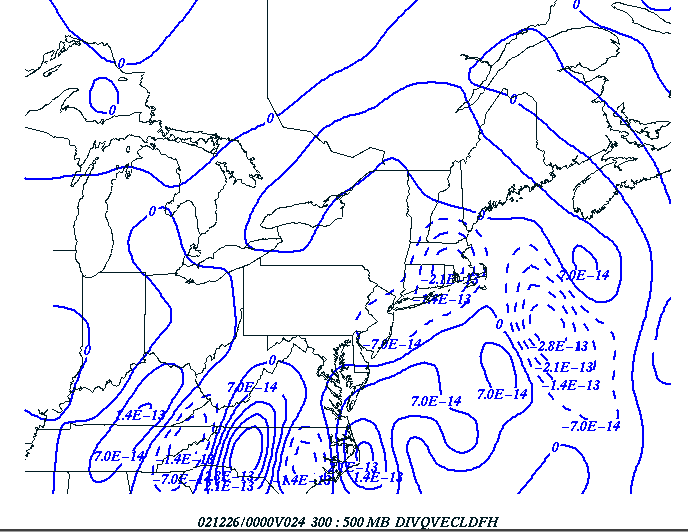
The next figures show the q vector divergence, omega and frontogenesis forecasts from the
Eta and GFS and workstation Eta (q vector divergence from the workstation Eta was not
available), all verifying at 00 UTC, 12/26/02.
12-hour GFS forecast of 300 to 500 mb q vector divergence verifying 00 UTC, 12/26/02.
12-hour Eta forecast of 300 to 500 mb q vector divergence verifying 00 UTC, 12/26/02.
A comparison between the q vector divergence shown by the Eta and GFS indicates that
the Eta showed more q vector convergence farther to the northwest than the GFS.
12-hour GFS 700 mb omega verifying at 00 UTC, 12/26/02.
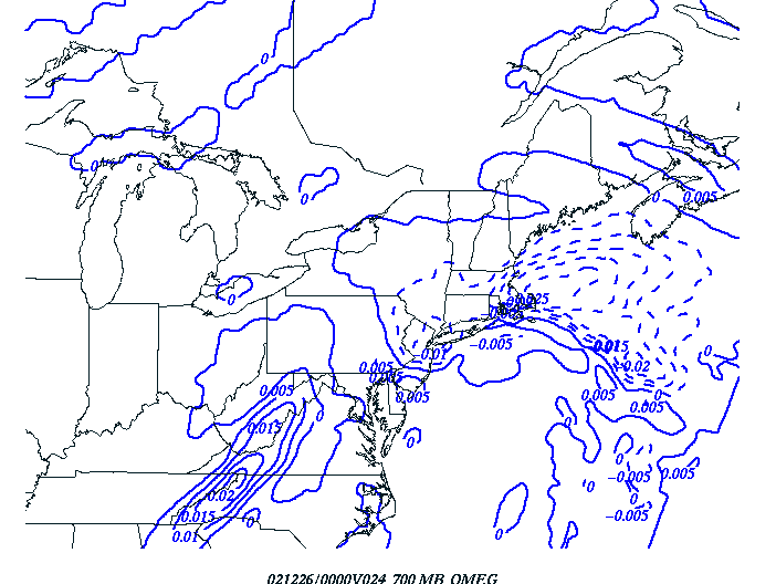
12-hour Eta forecast 700 mb omega verifying at 00 UTC, 12/26/02.
12-hour workstation Eta forecast 700 mb omega verifying at 00 UTC, 12/26/02.
In summary, the 700 mb omega patterns are similar to the q vector divergence patterns; ie
the Eta is forecasting more lift farther to the northwest than the GFS.
12-hour GFS forecast 700 mb frontogenesis verifying at 00 UTC, 12/26/02.
12-hour Eta forecast 700 mb frontogenesis verifying at 00 UTC, 12/26/02.
12-hour workstation Eta forecast 700 mb frontogenesis verifying at 00 UTC, 12/26/02.
The Eta forecast 700 mb frontogenesis maximum axis appeared to run from central Vermont
down to BGM. The workstation Eta and GFS maximum axis appeared to run from Massachusetts
down to northwest New Jersey. The workstation Eta indicated stronger values of
frontogenesis south of Maine than the GFS or Eta, but values were similar farther to the
west over western New England and eastern New York.
In summary, it appears that the Eta was farther northwest with its forcing, surface
low position and resultant qpf than the GFS and workstation Eta at this forecast cycle.
This trend appeared in other cycles as well.
4. The performance of the short-range ensemble forecasts
The figures in this section show the probability forecasts of 0.5 and 1.0 inches or more
of precipitation from the short-range ensembles for several runs prior to the onset of
the Christmas Day storm. The interpretation of these figures is as follows: if a figure
indicates a 70 percent chance of 0.5 inches of precipitation at a given location, than 70
percent of the short-range ensembles forecast at least 0.5 inches at that location. If a
100 percent chance is indicated, then every member forecast at least 0.5 inches.
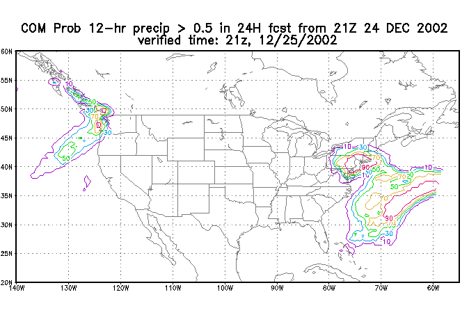
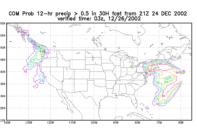
The first figures indicate the probability of 0.5 and 1.0 inches of precipitation
occurring in the 12 hours ending at 21z on the 25th, and 03z on the 26th, based on the
12/24 09z run of the short-range ensembles.
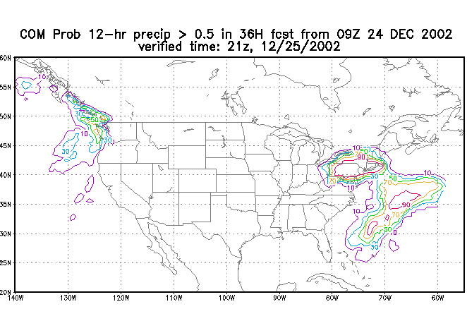
Probability of precipitation totals of greater than 0.5 inches for the 12-hour period
ending 12/25 21z.
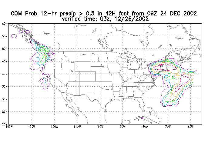
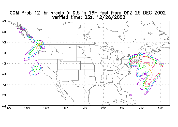
Probability of precipitation totals of greater than 0.5 inches for the 12-hour period
ending 12/26 03z.
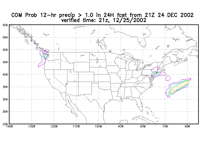
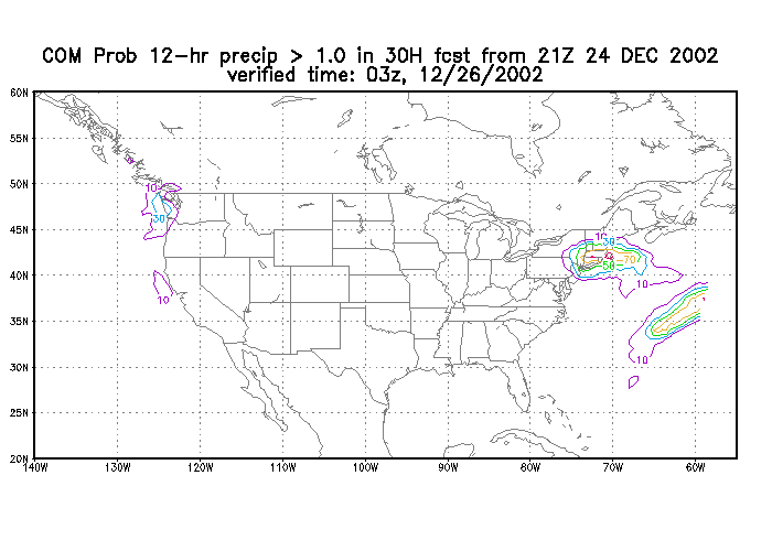
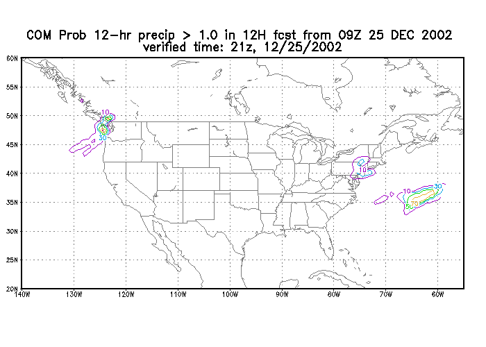
Probability of precipitation totals of greater than 1.0 inches for the 12-hour period
ending 12/25 21z.
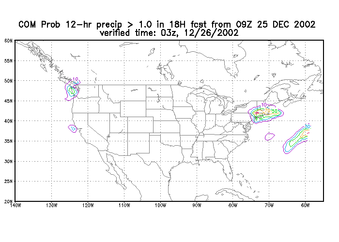
Probability of precipitation totals of greater than 1.0 inches for the 12-hour period
ending 12/26 03z.
The probability of greater 0.5 inch chart appeared to pin-point the area of heaviest
precipitation quite well, as the axis of maximum probability of 0.5 or more runs from near
BGM to near ALB. However, note that only a small percentage of the SREFs placed greater
than an inch of qpf in the proper area over east central New York.
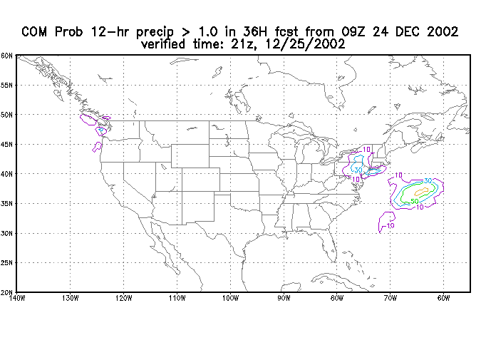
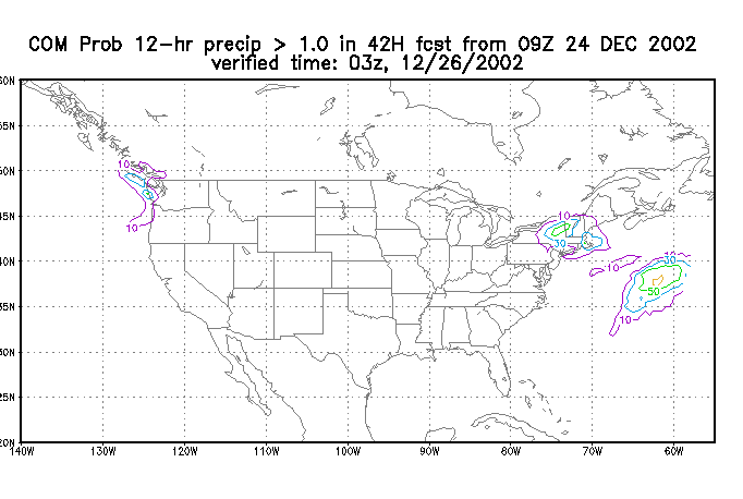
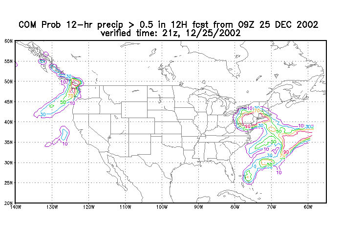
The next set of figures indicate the probability of 0.5 and 1.0 inches of precipitation
occurring in 12 hours ending at 21z on the 25th and 03z on the 26th, based on the 12/24
21z run of the short-range ensembles. This would have been the same data that would have
been available to the midnight shift forecaster during the time when the 00z 12/25 Eta and
GFS (shown in the previous section) were still showing a large difference in possible qpf's for this period.
Probability of precipitation totals of greater than 0.5 inches for the 12-hour period
ending 12/25 21z.
Probability of precipitation totals of greater than 0.5 inches for the 12-hour period
ending 12/26 03z.
Probability of precipitation totals of greater than 1.0 inches for the 12-hour period
ending 12/25 21z.
Probability of precipitation totals of greater than 1.0 inches for the 12-hour period
ending 12/26 03z.
Probability of precipitation totals of greater than 0.5 inches for the 12-hour period
ending 12/25 21z.
Probability of precipitation totals of greater than 0.5 inches for the 12-hour period
ending 12/26 03z.
Probability of precipitation totals of greater than 1.0 inches for the 12-hour period
ending 12/25 21z.
Probability of precipitation totals of greater than 1.0 inches for the 12-hour period
ending 12/26 03z.
Again, the axis of maximum probability of 0.50 inches or more appears to run from northeast
Pennsylvania across Connecticut in this run. The maximum of greater than an inch runs
across southern New York to northwest Connecticut, which was slightly south of the actual
axis of heaviest precipitation. Note that this latest run of the SREFs only indicates
about a 10 percent chance of an inch or more of precipitation for the northwest Catskills
from 15z on the 25th through 03z on the 26th.
SUMMARY
The Christmas Day snowstorm was generally well forecast by the models, with smaller
variation from model to model and run to run than what we sometimes see across the
northeast. Despite this, there were still some significant model differences, even less
than 24 hours prior to the onset of the storm. The Eta forecast appeared to be superior
in our area. Not only was the Eta forecast quite good with its placement of the
precipitation and strongest forcing, but Eta-based diagnostics were very helpful in giving
forecasters a "heads-up" on the potential for extremely heavy snowfall associated with
mesoscale banding. The forecast from the workstation Eta appeared to be more similar to
the GFS forecast than the Eta forecast, which might imply that differences between those
models were more a function of the model initialization, than the model physics. QPF
forecasts from the short-range ensemble forecasts were basically a compromise between the
too far south GFS and better Eta model, and as such the implied axis of heaviest
precipitation was a bit too far south.