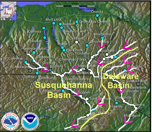
Major Rivers in Central NY and Northeast Pennsylvania
Notes:
In order to understand the historic response of the large, main stem rivers that occurred during this event, one needs to understand the topography of the area river systems. Northeast Pennsylvania and central New York contain two primary river basins; the Susquehanna River basin and the Delaware River basin. The Susquehanna River basin covers the western and northern part NWS Binghamton’s forecast/warning area, while the Delaware basin covers the southeast. Note that a portion of our forecast area also includes the Mohawk River basin, which is not included in this discussion.
The Susquehanna River originates near Cooperstown in central New York and flows southwest through southern New York, then southeast through northeast Pennsylvania to Wilkes Barre. Record flood crests were observed along the Susquehanna River in southern New York as the very heavy rain that fell over the western Catksill mountain region drained into the river system, then proceeded to flow downstream.
The Susquehanna River merges with the Chemung River in Athens, Pennsylvania, then continues southeast to Wilkes Barre. As a result, a major contributor to the water received in the Wilkes Barre area is from the Chemung River system, which originates northwest of Corning. The area northwest of Corning had less rain with this event than areas farther to the east. As a result, while historic flooding occurred over the upper Susquehanna River in New York state, the flooding farther south in the Wilkes Barre area, while significant, did not reach record levels. The main reason for this was that the contribution to the level of the Susquehanna from the Chemung river system was lower than what has occurred in some other events.
The Delaware River begins in the foothills of the western Catskills and flows southwest, then south along the New Jersey / Pennsylvania border. With very heavy rain falling across the headwaters of the Delaware in the western Catskills, record crests were observed along some Delaware River points.
The data on the following slides shows graphs of the river levels for several points along the Susquehanna and Delaware Rivers.